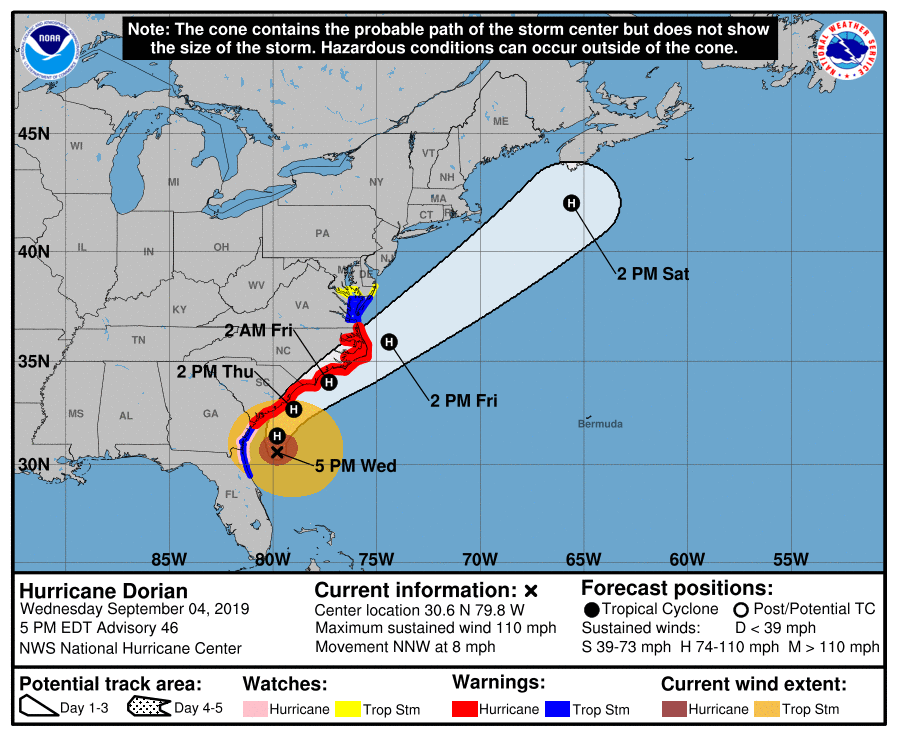
The outer bands of Hurricane Dorian are beginning to affect the North Carolina coastline as the category 2 storm is moving northward. Hurricane conditions are likely along coastal locations of NC through Friday morning.
Dorian remains a category 2 hurricane with winds of 110 mph. Dorian is currently moving north northwest at 8 mph. The direction is expected to change northward and then north norntheast on Thursday. The current track of Dorian is very close to Morehead City and Cape Hatteras on Friday Morning. Landfall is possible along the NC coast Thursday afternoon to Friday afternoon.
The NAM simulated radar shows the expected track of Dorian. Conditions will continue to deteriorate during the overnight hours as Dorian moves northward Thursday. The worst weather will begin in the southeastern counties and move northward through Thursday into Friday.

The wind field with Dorian will also bring Hurricane force winds and wind gusts to coastal areas. The strongest winds are expected along the coastline, with tropical storm force winds further inland. The National Weather Service issued the image below Wednesday morning, and it shows the estimated peak wind gusts from Dorian.


The other main threat will be the very heavy rain. 6-12 inches of rain is expected across parts of the coast of NC. Flash flooding is likely due to very heavy rain in a short period of time.

Another threat will be the storm surge. Right now is a period of King Tides along the coast, which means high tides are higher than normal. Flooding due to strong storm surge is also possible across the beaches and towns in NC.
By Friday evening, Dorian is expected to be pulling away from the coastline. Be sure to remain weather aware and take all necessary precautions. Dorian remains a very strong storm and is expected to cause damage across eastern NC.
